33.18°N 96.50°W | Princeton, TX

RAMY ALYATIM

Systems Builder

I build |
"

I'm a geospatial engineer who builds spatial data pipelines: sourcing, transforming, and delivering authoritative spatial data into tools people actually use.

I started in GIS because maps are more than visuals; they're interfaces for understanding the real world. Over a decade, that evolved into building full systems: data pipelines and dashboards relied on by decision-makers, mobile field data collection platforms, IoT command centers, and operational tools for working businesses.

AI tooling is part of how I work every day. I use Claude Code and the Anthropic API to generate, optimize, and automate spatial workflows, from geoprocessing scripts to full pipeline code, always with human review on the output. The common thread in everything I ship is making systems clearer, faster, and more actionable.

I'm most excited by problems where software, data, and the physical world intersect, and where the network can't be trusted: everything I build assumes you'll lose signal. Off the clock I'm an overlander, mountain biker, and upland hunter. I build the kind of geospatial data I depend on in the field.
Approach

How I Solve Problems

The same methodology, applied from federal programs to commercial products to my own field projects.

01

Observe

Sit with the users. Feel the friction. Understand what's actually happening, not what's documented.

Security Operations

Watched guards struggle with paper logs and text-based reporting: no structure, no accountability.

02

Decompose

Break the problem into solvable pieces. Identify what's core vs. noise.

Real Estate Analysis

Separated flood inundation data from legal interpretations: automated the former, preserved the latter for experts.

03

Build

Prototype fast. Use the simplest tools that work. Don't over-engineer before validation.

Farm Operations

Started with spreadsheets, evolved to custom tracking software only after validating the data model.

04

Deploy

Get it in real hands. A dashboard no one uses is worthless; adoption is the metric.

Field Operations

Field-built operations dashboard received thousands of views and was handed to a dedicated maintainer.

05

Iterate

Measure what matters. Listen to feedback. Improve based on reality, not assumptions.

Retail Automation

Continuously refined label generation based on actual store workflows and edge cases.

Experience

10+ years building geospatial data pipelines and solutions across federal, defense, and commercial products.

Product Engineer, Defense Solutions

Esri

Current
RemoteMay 2026 – Present

ArcGIS Solutions for Defense

Configuring ArcGIS apps, tools, workflows, and information models for defense and intelligence organizations

Operational workflows solved with product configuration instead of one-off custom development

Workflow Discovery & Design

Working with defense customers and industry teams to translate real operational workflows into solution patterns

Customer needs carried from discovery through design, documentation, and release

Solution Quality & Testing

Designing and executing manual and automated test cases across solution releases

Release readiness assessed against real defense workflow requirements

Lead Cartographer / Knowledge Manager

U.S. Army Corps of Engineers (USACE)

Seattle, WASep 2019 – May 2026

Seattle District Real Estate Dashboards

Built real-time dashboards tracking Corps-owned fee and non-fee real estate assets

Used daily by Seattle District leadership for management and planning decisions

FUDS / UXO Multidistrict Dashboard

Developed multidistrict dashboard for Formerly Used Defense Sites operations

Enabled teams to identify and prioritize UXO remediation on private lands

Takings Analysis Automation

Automated geoprocessing workflows converting inundation rasters into actionable polygons

Reduced manual processing from hours to minutes with standardized outputs

Innovator of the Year (2022)Real Estate Professional of the Year (2022)

Geospatial Engineer

U.S. Army Corps of Engineers (USACE)

INDOPACOM, SOUTHCOM & CENTCOM Deployments2021 – 2025

FEST-A INDOPACOM Operations Dashboard

Designed map-centric dashboard for EDCA infrastructure projects across the Philippines

Thousands of views during active ops; handed off to dedicated INDOPACOM maintainer

Real-time Geospatial Support

Provided field GIS support for engineering, logistics, and infrastructure planning

Enhanced situational awareness for combatant commands and foreign military partners

Civilian Service Commendation Medal (2021, 2023, 2025)

Geographic Information Systems Analyst

Harris Govern

Allen, TXSep 2015 – Sep 2019

Automated GIS Workflows

Developed Python scripts and ModelBuilder tools for geospatial data processing

Automated cadastral data processing, geocoding, and map production workflows

Technical Training

Provided training on CAMA software and property valuation mapping

Guided county officials in GIS data integration and property mapping

Track Record

Recognition & Career Progression

GS-07 → GS-12 in 2 years. Sustained recognition across deployments.

2026
Joined EsriProduct Engineer, Defense Solutions
2026
Completed 6+ years at USACESeattle District
2025
Civilian Service Commendation MedalUSACE Deployment
2023
Civilian Service Commendation MedalUSACE Deployment
2022
Innovator of the YearSeattle District USACE
2022
Real Estate Professional of the YearSeattle District USACE
2021
Promoted to GS-12Seattle District USACE
2021
Civilian Service Commendation MedalUSACE Deployment
2020
Promoted to GS-11Seattle District USACE
2019
New Employee of the YearSeattle District USACE (GS-09 & below)
2019
Started as GS-07Seattle District USACE
Promotion
Award / Commendation
FIELD ATLAS // CAREER TRIP LOG
8 WAYPOINTS // 5 COUNTRIES // 85,000 KM ROUTED
The Journey

A DECADE IN THE FIELD

From Texas county parcels to Pacific operations and back. Scroll to follow the route.

WP 01 // Origin33°06'11"N 96°40'14"W

Allen, TX

GIS Analyst, Harris Govern

Sep 2015 – Sep 2019

Where it all started. Four years of county-scale cadastral mapping: COGO boundary construction, legal description analysis, and the first Python scripts that turned days of manual map production into minutes.

WP 02 // The Enterprise Years47°36'22"N 122°19'56"W

Seattle, WA

Lead Cartographer / Knowledge Manager, USACE

Sep 2019 – May 2026

Six-plus years owning authoritative regional datasets for the Seattle District: enterprise geodatabases on PostgreSQL and SQL Server, takings-analysis automation that cut hours to minutes, and dashboards leadership used every day.

New Employee of the Year, 2019Innovator of the Year, 2022Real Estate Professional of the Year, 2022
WP 03 // First Deployment29°22'33"N 47°58'39"E

Kuwait

Geospatial Engineer, FEST / CENTCOM

2021

First rotation with a Forward Engineer Support Team. The operations dashboard prototyped here became the blueprint that later scaled across an entire theater.

Civilian Service Commendation Medal, 2021
WP 04 // Cross-Agency Ops04°42'40"N 74°04'20"W

Colombia

Geospatial Engineer, ARSOUTH Support

2021, 2023

Two rotations supporting U.S. Army South: cross-agency coordination and field GIS operations in the Andes.

WP 05 // The Proving Ground14°35'58"N 120°59'03"E

Philippines

Geospatial Engineer, EDCA Infrastructure Program

2023, 2024

Two rotations supporting EDCA facility construction. Built the INDOPACOM operations dashboard that drew thousands of views during active operations and was handed off to a dedicated maintainer, a rare outcome for a field-built tool.

Civilian Service Commendation Medal, 2023Civilian Service Commendation Medal, 2025
WP 06 // Joint Task Force14°04'20"N 87°12'23"W

Honduras

Geospatial Engineer, JTF Bravo / CERTEX

2025

CERTEX rotation providing geospatial engineering support to Joint Task Force Bravo in the Honduran highlands.

WP 07 // Final Rotation13°26'39"N 144°47'37"E

Guam

Geospatial Engineer, CREST / Missile Defense

2025

Built the CREST Operations Dashboard for the Missile Defense Agency's Flight Experiment Mission, supporting contingency real estate work in the Pacific.

WP 08 // Basecamp33°10'48"N 96°29'54"W

Princeton, TX

Product Engineer, Defense Solutions, Esri

May 2026 – Present

Home base. Configuring ArcGIS Solutions that turn defense workflows into deployable products at Esri, with a homelab full of field hardware on the side: an instrumented citrus tree, a voice-and-vision bench assistant, and a travel trailer that maps its own trips. I build the kind of geospatial data I depend on in the field.

Applied Research & Projects

End-to-end systems built to solve real problems, from identifying the gap to shipping working software. Click any project for details.

01
2025–Present
Offline-First Field Operations

Disaster-Response Field Ops Platform

Problem

Recovery crews working post-disaster zones operate where the cell network went down with the buildings. Paper work orders, lost photos, and duplicate records make program reporting slow and error-prone.

Solution

Helped build an end-to-end field platform as one of three partners in a geospatial software firm: an offline-first React Native app with durable sync, a web QC portal, and PostGIS dispatch with clustering and route optimization.

In delivery for a disaster-response program: offline sync engineered and tested for zero duplicate submissions, crew routing that clusters 500 sites in ~30ms, drive-time isochrone planning.

React NativeMapLibre GLPostGISSupabaseExpoTypeScript
02
2024–Present
IoT & Embedded Systems

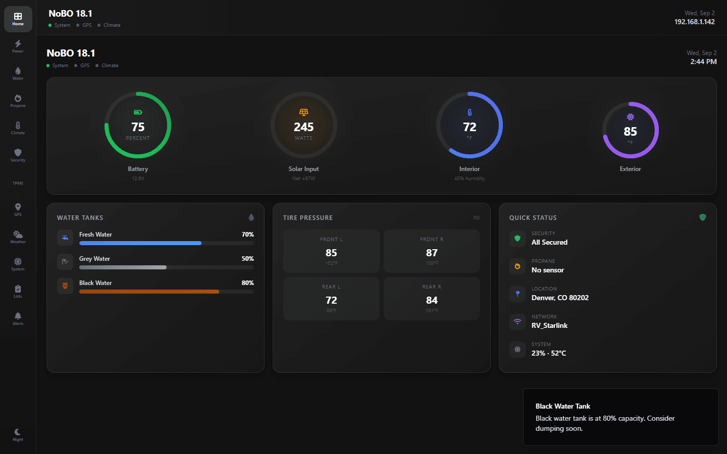
Smart RV Command Center

Problem

Off-grid RV travel means managing critical systems where there is no connectivity: battery health, tank levels, tire pressure, and navigation, with no unified visibility or proactive alerting.

Solution

Built a command center on a Raspberry Pi 5 touchscreen: a fully offline ESP32 Bluetooth sensor network, live GPS tracking on USGS topo maps, and a server-side trip engine that detects driving, pauses, and camp arrivals automatically.

Deployed in my 18ft travel trailer: ~$90 sensor network vs $300+ commercial alternatives; auto-detected trip logs with GPX import/export; 12-tab touchscreen dashboard; 22 unit tests on the geo math.

ReactTypeScriptMapLibre GLRaspberry PiESP32Python
03
2026
Vision-Only Autonomy

Autonomous Drone Racer

Problem

The AI Grand Prix racing league requires fully autonomous drones to thread race gates at speed with no GPS, no absolute position, and no human input: one camera and an IMU.

Solution

Built the full autonomy stack: classical computer-vision gate detection, state estimation, spline trajectory planning, a 90 Hz geometric flight controller over MAVLink, and a reinforcement-learning agent for the simulation phase.

Flew a verified clean Virtual Qualifier run: 6/6 gates in 00:37.192, official qualification pending. The SAC agent solved the mock simulator with 10/10 finishes on random tracks across 25+ documented training runs.

PythonOpenCVPyTorchMAVLinkReinforcement Learning
04
2023–Present
Security Operations SaaS

PatrolSmart

Problem

Security company owners struggle with administrative overhead, guards lack efficient real-time reporting tools, and clients have no visibility into operations at their sites.

Solution

Built a cloud-based, multi-tenant security operations platform with an Admin Web Dashboard for managers and a Mobile Collector App for guards to submit GPS-tagged incident reports with photos.

Reduced incident report turnaround from hours to seconds; GPS-tagged field reports feed a live Mapbox dashboard in real time. In private beta with one agency.

ReactMapboxFirebaseReact NativeTailwind
05
2026
Voice + Vision Edge AI

Jarvis Bench Assistant

Problem

Electronics bench work stalls constantly: wiring lookups, component identification, a third hand you don't have. Cloud voice assistants can't see the bench, and they die with the WiFi.

Solution

Built a voice-and-vision AI lab partner on a Raspberry Pi 5: wake word, speech-to-text, and speech output all run locally, with Claude as the reasoning brain, an overhead 16MP camera for vision turns, and AI-drawn wiring diagrams on a touchscreen HUD.

Deployed over the bench via systemd with git push-to-deploy: 0.94+ wake-word confidence, ~2s on-device speech recognition, and streaming replies that start speaking while the model is still writing.

Raspberry PiPythonAnthropic APIopenWakeWordfaster-whisperOpenCV
06
2026
Outdoor Sensing & Telemetry

The Instrumented Tree

Problem

A citrus tree hides water stress until the leaves drop, and by then the damage is done. Consumer plant sensors answer with cloud apps that die when the WiFi does, and none of them survive a Texas summer outdoors.

Solution

Instrumented a calamondin citrus tree with an outdoor-hardened ESP32 sensor node (air, light, soil moisture, root-zone temperature) streaming into Home Assistant on a self-hosted Proxmox server, with a custom React dashboard that computes plant health from the physics.

Transpiration early-warning from a $13 soil sensor: a least-squares regression over 48 hours of moisture data flags a stressed tree days before visible symptoms. ~$87 total sensor BOM, LAN-only by design.

ESP32ESPHomeHome AssistantProxmoxReactTypeScript
07
2023–Present
Workflow Automation

ShelfLabelBuilder

Problem

Independent liquor and convenience store owners, typically 1-3 person operations without IT departments, spend 2-4 hours weekly repricing products manually with handwritten tags or generic Word templates.

Solution

Built a full-stack SaaS web application with companion mobile app that lets retailers design professional shelf labels with a WYSIWYG editor, manage product inventory, and batch-print to both sheet labels (Avery) and thermal printers.

~2-3 hours/week saved per user on label creation; 50,000+ built-in product catalog; $129/year SaaS launched with 14-day free trial; actively deployed on Vercel/Supabase.

ReactTypeScriptPostgreSQLStripeReact Native
3 screenshots available
08
2024–Present
AgTech Operations

Dumalan Mushroom Farm

Problem

Small-to-mid-sized specialty mushroom farmers, typically 1-5 person operations, track everything in spreadsheets, whiteboards, and paper logs with no enterprise software options.

Solution

Built a full-stack operations dashboard that tracks mushroom cultivation from sterilization through sales, with role-based access for farm owners, technicians, and sales staff.

~5 hours/week saved on manual tracking; contamination visibility revealed most losses occurred post-inoculation, leading to process changes. In active development toward commercial launch.

ReactTypeScriptPostgreSQLDrizzle ORMExpress

Technical Proficiencies

Core competencies spanning spatial data pipelines, geospatial analysis, and application development.

PostgreSQL / PostGIS / Spatial SQL
Python Geoprocessing & Automation (arcpy, pandas, GDAL/OGR, geopandas)
AI-Accelerated Workflows (Claude Code, Anthropic API)
ArcGIS Pro & Enterprise
QGIS
Web GIS & Dashboards (Mapbox GL, React)
Remote Sensing & LiDAR
React / React Native / Node.js
UAV Photogrammetry
Enterprise GIS Administration
GEOINT
Cloud (AWS, Azure, Supabase)
The Pitch
I've built operational systems under real constraints:for military commands, for enterprise products, and for my own ventures.

I'm looking for roles where I can deploy into ambiguous environments, work directly with operators, and build systems that matter.

This Site Is Instrumented

Field Guide

Working instruments and a few easter eggs, all running in your browser. Field tools should reward the curious.

`

Field Terminal

Press the backtick key anywhere. Try 'whoami', 'deployments', or 'sudo hire'.

GPX

Map Your Own Route

Drag any .gpx file onto the page. Your track renders on 3D terrain with stats, parsed locally.

MIC

Voice Commands

Type 'voice' in the terminal and speak. Local recognition, just like my bench assistant.

ISS

Orbital Tracking

Type 'sky' in the terminal for the space station's live position and distance from basecamp.

VSH

Terrain Lab

Live viewshed and grade-profile analysis, computed in your browser from open elevation data. Click here or type 'lab'.

GRID

Map Collar

Mouse over the Journey map for a live MGRS grid reference, magnetic declination, and USGS ground elevation under your cursor.

OFF

Works Offline

Lose your connection. The site keeps loading from cache, like everything I build.

???

Classified

There's a flyover authorized for those who know the classic code. Pilots will figure it out.